http://capeyorkpeninsula.blogspot.com.au
Cape York 10 – 19
September 2012 with Frontier Safaris
Peter & I left Melbourne on 7
September to spend 3 nights with brother Graham & his wife Julie in
Cairns. Peter’s sister Helen and her
husband Howard were in Atherton visiting their son Philip and his family. The 6
of us were able to enjoy lunch together at Malanda on Saturday 8 September.
 |
| Graham & Julie, Howard & Helen, Peter & Joy at Malanda |
Day 1.
Monday 10 September
we flew from Cairns to Horn Island with Qantas Link for a 9 day fly/drive
safari tour of Cape York Peninsula.
There were 15 of us which included 7 of us from our local gym (Janet
& Ray, Mary & Geoff, Gerry).
Kerry & Lindsay were from Perth and deaf which was an interesting
experience for us all, John & Bernie were from Inverlock. Mark & Ann were from Sydney and Marilyn
& Steve from Parkdale. (They joined
us at Seisia as they had come from Cairns on the cargo ship “Trinity”. Our cook
Ingrid from Adelaide and driver Bruce from Melbourne were at Seisia to greet
us).
 |
| Boarding our QantasLink flight from Cairns to Horn OIsland on 10 September 2012 |
 |
| Flying over Thursday Island before arriving at Horn Island |
As we were about to land at Horn
Island, suddenly we were lifting off again – what a strange feeling. Apparently
a flock of birds prevented the plane from landing. The extra fly-over of the islands was lovely. Horn Island extends over 53 square kilometres
and one of the biggest islands of the Torres Strait, with a population of 900. The
eleven of us were given a tour of the “Torres Strait Heritage Museum” which has
a large collection (5000 items) of WW11 artefacts and photos, cultural and
artistic items. We saw a video “Heroes of Horn Island”. Horn Island played a major role in WW11 in
defence of Australia. It was the 2nd
most bombed location after Darwin. The airstrip was once a frontline base for
Allied troops. Today it links Torres
Straits with Australia. We were taken on
a tour showing us relics of WW11 with slit trenches, crashed aircraft, a
Command Post and octagonal gun pits built in 1942. We even saw an old beer bottle from 1942
still lying on the ground. Back to the
Museum for a lovely lunch, then a quick ferry ride to Thursday Island and a
large one from Thursday Island to Seisia 40kms from the Tip of Australia. It
was quite windy (25 knots) with lots of spray so by the time we reached Seisia
75 minutes later we were drenched and quite cold.
 |
| Joy & Peter at Torres Strait Heritage Museum, Horn Island |
 |
| Slit trenches used WW11 |
 |
| Gun pit stands empty today where once stood 3.7 inch gun |
 |
| Joy at entrance to 34th Heavy Anti-Aircraft Battery Command Post |
 |
| Peter holding a 1942 beer bottle found on the ground |
Met by a driver Bruce and cook Ingrid we were soon instructed on how to
put our tents up. Seisia camp ground is
on the beach so we had our tents set up with great views of the Torres Straits
and just 20 metres from the water line. One could say “paradise”, but the
crocodile warning sign said we could not enter the water!
 |
| Our camp site at Seisia, overlooking the Torres Straits |
 |
| Janet & Ray, Peter relaxing at Seisia |
 |
| Sunset at Seisia Camping Ground |
We were greeted with the news
that 50kms south the Punt which transports vehicles across the Jardine River
had met with an accident on 10 September.
A large semi-trailer loaded with gravel had attempted to board the Punt,
breaking the cables and stays that control the Punt, thus putting it out of
action for an unspecified time. That
meant we were stranded and unable to go south.
At least we had a comfortable and pleasant camp location with toilets
& showers and camp kitchen, while those stranded on the south side of the
Jardine River only had 2 toilets and no provisions. It was a wait and see situation.
 |
| Truck in Jardine River and broken Punt |
Bruce was very sensitive as he told
us about his frustrations and dilemma on his last tour of 20 August 2012, which
got quite nasty and ended abruptly. Was
history going to repeat itself was at the forefront of Bruce’s mind. On Day 3 the tour left Seisia just as we were
scheduled to, but only got 30 minutes down the road when the bus had an electrical
malfunction, leaving the passengers stranded for 3 hours on the side of a very
dusty inhospitable road. The vehicle was
towed back to Bamaga and the passengers were transported back to Seisia Camping
Ground in a hired school bus. It was a
full 24 hours before the vehicle was repaired, so the following day the group
set off again, but the electrical system failed again, leaving the passengers
stranded by the roadside for 5 hours.
The passengers were once again returned to Seisia camp ground. Attempts to again repair the 2 year old
vehicle were made, but it was determined to return it to the manufacturer in
Cairns as it was still under Warranty.
At that point the 12 guests were offered a choice of either continuing the tour
in a similar vehicle which had been sourced, but with a modified itinerary, or to be flown back to Cairns at the Company's expense. Four guests wanted to continue with a modified itinerary, but 8 wanted to be flown back to Cairns. The Company went with the requests of the majority. This is why Travel
Insurance is advisable! Outback Australia
can be dangerous and unpredictable. It
was unfortunate that this group could not “go with the flow”, whereas our group
had a very accommodating attitude to the circumstances and saw it as an
Australian outback experience “not to be missed”. It was a bonding experience and we are all
the richer for it.
 |
| Bus with electrical malfunction on 23 August 2012 |
Day 2.
Today we drove the
40kms to the Tip of Australia, taking 2 hours on a very corrugated road that
was quite narrow at times and with some water crossings. The first car to reach
the Tip of Australia was in 1928.
Francis Birtles rode (and often carried) a bicycle from Cairns to the
Tip in 1918. We walked 400metre over a rocky outcrop to the Tip of Australia
which is surrounded on 3 sides by water, the Coral Sea to the East, Torres
Strait at the tip and Gulf of Carpentaria on the West. We had our photo take
standing at the northern most point of the Australian Continent. It was windy and light rain fell for about 10
minutes just when we were at the Tip. The Great Dividing Range rises at the Tip and
follows the east coast all the way south.
 |
| Driving the 40 kms to Tip of Australia - it took 2 hours |
 |
| Driving to the Tip of Australia |
 |
| 400 metre walk over rocky outcrop to Tip of Australia |
 |
| Peter & Joy standing at the northernmost point of the Australian Continent |
 |
| Geoff & Mary, Ray & Janet, Joy & Peter at the Tip |
Bruce took us to see a couple of
WW11 crashed planes near Bamaga, 6kms away.
It was interesting to see some fuel dump dispersal areas where they hid
the 44 gallon drums of fuel to avoid detection by enemy planes. The fuel drums arrived on barges and loaded
onto trucks and taken to different locations during WW11.
 |
| Bristol Beaufort Mark V111 crashed near Bamaga WW11 |
 |
| Fuel dump dispersal area |
Day 3.
Today we were
scheduled to move south but it could be a few more days before the Punt is
fixed. It was agreed that the Company
would give us an extra day to make our way back to Cairns, but with
modifications to our itinerary. We would
have to miss out on Weipa and some other spots along the way and travel longer
days. No decisions could be made until
news of a repaired Punt had reached us.
It was a waiting game and we waited until Day 7before we could depart
south. The road distance for the Tip to
Cairns is 950kms without detours and usually recommended to take 1 week to
drive. (We travelled 1200kms all
together and took 4 days to drive 900kms).
We relaxed at the camp site, talked, cat-napped,
ate and took small walks but it was fairly hot.
It was frustrating that we could not go for a swim. Happy hour was at dusk on the beach with a
late dinner. The sunsets over the sea
were lovely.
 |
| Stranded in paradise for 6 days (Seisia) |
 |
| Happy Hour on the beach |
 |
| Happy Hour on the beach |
 |
| Sunset in paradise (Seisia) |
Day 4.
Today was Joy’s 69th
birthday. A group of us arranged to go
by Ferry “Strait Magic” to Thursday Island which has a population of 3500 and
covers 3.4 square kms. We went to Green Hill Fort built 1893 and from there saw
great views of Horn, Prince of Wales, Hammond & Fridays Islands. There is an excellent museum of military artefacts. The historic cemetery was a reminder of the
long forgotten Japanese pearl shell divers.
Quetta Memorial Church, the smallest Cathedral in the World, built 1893 in memory of the
sinking in 3 minutes of SS Quetta – 293 on board, 133 lost. A life ring and
bell are on display at the church. We
spent time at the Gab Titui Cultural Centre, established 2004 to preserve
Torres Strait culture and promote indigenous art - wood carvings, paintings
jewellery & head dresses. Eight
hours later we were on “Strait Magic” and heading back to Seisia. At dinner a frozen cheesecake with candles was
produced with the chorus “Happy Birthday” sung by all.
Louis Van Torres was the 1st
non-indigenous sailor to navigate Torres Strait, followed by Captain James Cook
who claimed the area on behalf of the British Crown – now Possession
Island. There are over 200 islands in
Torres Strait – most of which are uninhabited.
Thursday Island is the main administrative centre. Torres Shire is a shire literally on the
sea. The main form of transport is by
boat. The Torres Strait Islanders number
24,000. They are a happy friendly people.
 |
| Arriving at Thursday Island on board "Strait Magic" |
 |
| Welcome to Thursday Island |
 |
| Green Hill Fort built 1893 |
 |
| Historic cemetery where many Japanese pearl-shell divers are buried |
 |
| Quetta Memorial Church built 1893 - smallest Cathedral in the world |
Day 5.
Still stranded at
Seisia but there was a distraction this morning. A crocodile had been up on the beach. Last night a fisherman had caught a 2 foot
shark, cut its head off and left the body on the beach. That is not advisable when crocodiles are
around. The crocodile had come up on the
beach just 50 metres further down from our tents and within just a few metres
of the camping ground. It was
interesting to see its slide marks and footprints in the sand. Another 2 crocodiles were seen in the water
which reinforced they were around and we should not be tempted to swim or even
paddle. Some of us including Joy did
cautiously paddle at times.
 |
| Crocodile came up the beach close to campers |
 |
| Crocodile footprints and slide marks |
 |
| Crocodile watching |
 |
| Crocodile watching from our camp |
News was reaching us that the
Punt MAY be fixed by tomorrow. Bruce endeavoured to reassure us that if we
had to be stranded that we were in the best place. At least we had toilets & showers, food
and a glorious view while those 100s or 1000s stranded on the south side of the
Jardine were without showers and food.
Seisia Camp Ground helped out with provisions. Frontier Safaris were prepared to extend our
tour by an extra day, but we would still miss out on some of the highlights
like Weipa and we would have to travel long days to still make it back on Day
10. Tonight was a special treat from
Frontier Safaris – we went to the Fisherman’s Club for a hamburger. The sunset
was lovely.
Day 6.
Still stranded, but
news is that the Punt is nearly ready for use.
Finally just after lunch the good news reached us that all was OK
again. Many 4WDs were packing up and
making their exit. Bruce did not want to
travel the 50kms south to the River (which would take about 2 ½ hours) on a
very corrugated dusty red road along with everyone else until the next day.
Day 7.
We were up about
5.30am and left camp about 7am for our departure south – 4 days later than
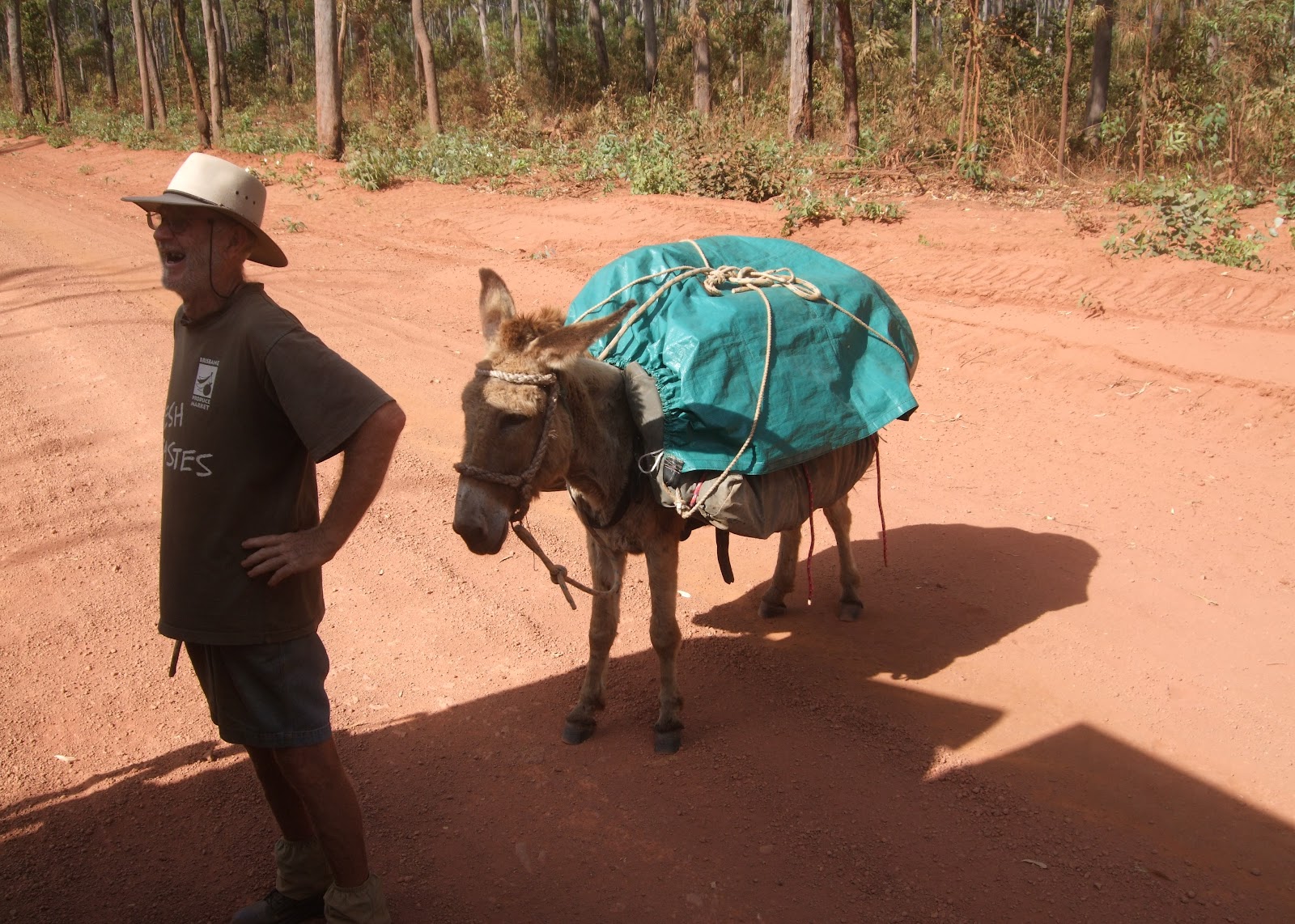
scheduled. We met Noten and his donkey
Esther on the road. Noten had walked
from Wilson’s Promentary in Victoria (left late 2010) to reach the Tip of Australia (mid August 2012), and now heading back south to Cairns where he will say goodbye to Esther and fly to Melbourne for Christmas 2012.
 |
| Crossing Jardine River on the repaired Punt |
 |
| We made it to the other side - now we can head south to Cairns in 4 days |
 |
| Noten and his donkey Esther |
We had a quick swim in the crystal clear
water at Fruit Ball Falls. We drove 220kms along the Telegraph Road to Bramwell
Junction Roadhouse for a late lunch where there were many termite mounds. Nearby was a 7.2 metre high termite mound –
good for a group photo. We arrived late
in the afternoon (250kms from Seisia) at Moreton Telegraph Station, established
1887 and closed 1987 with the introduction of the modern era of
telecommunications. A walk around the 15
acres of cleared land for camping was pleasant and a look at the Wenlock River
which is said to be where Steve Irwin has caught many crocodiles in the past.
 |
| Swimming at Fruit Bat Falls |
 |
| Bramwell Junction Roadhouse |
 |
| Group at 7.2 metre Termite Mound near Bramwell Junction |
 |
| Camped at Moreton Telegraph Station, established 1887 |
Day 8.
Up early with
eucalyptus scrub, anthills and water crossings along the 225kms Development
Road between Moreton and Musgrave. We
stopped at Coen for a quick visit to the Cape York Heritage House which houses
lots of memorabilia. The town was
founded as a Fort on the river in 1873 and grew with the gold rush 1890-1916.
Ingrid found a lovely lunch spot by the Coen River.
 |
| Between Moreton and Coen |
 |
| Development Road between Coen and Musgrave |
 |
| Great Dividing Range rises at theTip and follows east coast all the way to the south |
 |
| Lunch spot near Coen |
 |
| Collecting firewood |
We collected firewood before entering the
Lakefield National Park which was an amalgamation of 3 huge cattle stations,
now a haven for many birds and animals native to the area. Lagoons, billabongs, and wide river lakes are
home to both fresh and saltwater crocodiles.
Our camping ground at “Kalpowar” was overlooking the Normanby River – a
lovely spot but we could not linger.
 |
| Lakefield National Park |
 |
| Termite Mounds in Lakefield National Park |
 |
| Lakefield National Park |
Day 9.
We were up to see the
sun rise over the hill, and with the Normanby River and Kalpowar Causeway below
it was a sight to behold. Egg and bacon
for breakfast was a treat and many of us enjoyed the view while having coffee. As we left we saw a warning sign saying that a
crocodile had recently been seen in the area!
Bruce stopped the bus at another
part of the Normanby River in the hope of seeing a crocodile but all we could
see were slide marks. Nevertheless the
reflections in the river were magnificent.
 |
| Normanby River at "Kalpowar" Lakefield National Park |
 |
| Causeway over Normanby River at "Kalpower" Lakefield N.P. |
 |
| Reflections in Normanby River at Lakefield National Park |
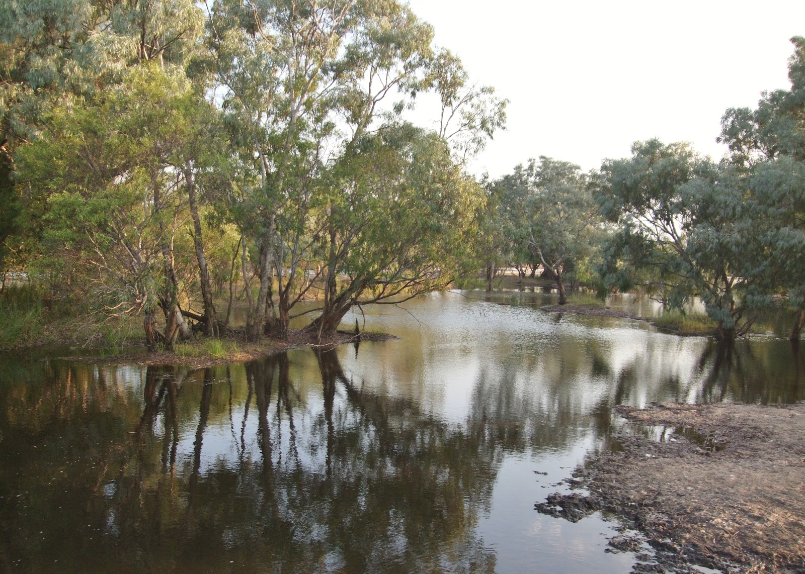
We visited “Old Laura” Homestead.
Fergus O’Beirne purchased land in 1879.
By 1894 he was running 8000 cattle.
By 1960 the property has deteriorated.
Today it stands as a tribute to the hardy pioneers of the Cape York
Peninsula.
 |
| The men at "Old Laura" Homestead |
 |
| "Old Laura" homestead built 1879 |
A drive over Battle Camp
Range with some small river crossings took us into Cooktown for a very late
lunch at Cooktown Caravan Park – civilisation and a lovely toilet/shower
block. Bruce took us to Grassy Hill
Lighthouse overlooking Cooktown, it was built in England and shipped to
Cooktown in 1885 and automated in 1927.
 |
| Built 1885 - Lighthouse at Grassy Hill, Cooktown |
 |
| View from Grassy Hill looking north to Battle Camp Range |
A quick but interesting visit to
James Cook Museum where the anchor from Captain Cook’s “Endeavour” was
recovered in 1971 – 200 years later. A
canon was recovered in 1969. On 26 August 1768 Captain James Cook in command of
H.M.S.”Endeavour” set sail from Plymouth on his first circumnavigation of the
world with a royal commission to make astronomical and botanical observations
of the South Seas. On 10 June 1770
“Endeavour” ran onto jagged coral, resulting in a gaping hole in her hull,
40kms south of Cooktown. Cook tied up in
Cooktown 18 June and set sail again after repairing his ship on 4 August 1770.
The tree used to moor his ship is also in the Museum.
Our farewell dinner was
celebrated at Cooktown Bowls Club.
 |
| Canon from Captain Cook's "Endeavour" recovered 1969 |
 |
| Anchor from "Endeavour" recovered 1971 |
 |
| Captain James Cook tied up in Cooktown June 1770 |
 |
| Tree used to moor "Endeavour" while under repairs June 1770 |
Day 10.
Black Mountain
National Park is 25kms south west of Cooktown at Helenvale. It’s
distinctive dark appearance is due to a film of lichen. Cape York’s iconic Pub “Lion’s Den Hotel”, was
built in 1875 from iron and timber and is surrounded by 100 year old mango
trees. It has heaps of quirky
decorations and walls adorned with signatures.
A haven for 4WD vehicles and their drivers! Wujil Wujil was of particular interest to us
as Peter’s brother had lived there some years ago. Bana Yirriji Arts and Cultural Centre is new,
showing off locally indigenous made arts and crafts.
 |
| Black Mountain National Park |
 |
| Interior Cape York's iconic Pub, Lion's Den Hotel built 1875 |
 |
| Aboriginal art at Bana Yirriji Arts & Cultural Centre Wujil Wujil |
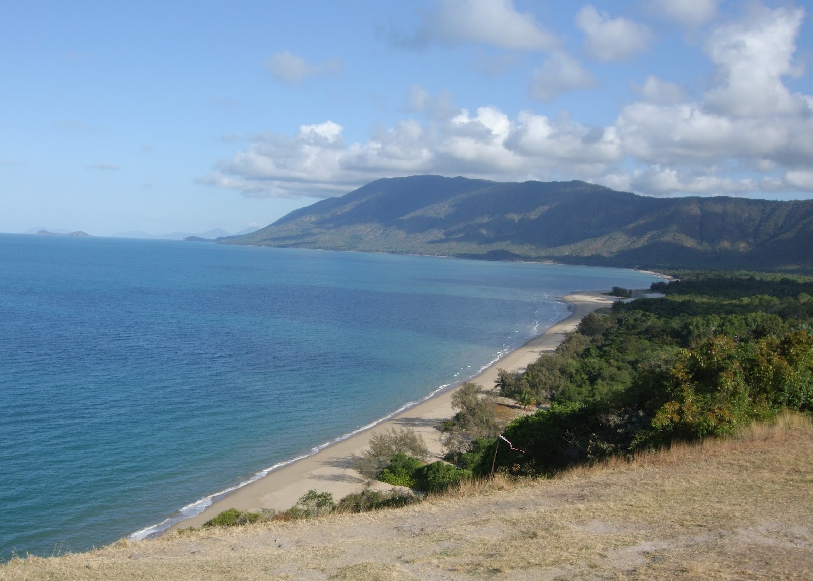
Bloomfield Track is a 4WD coastal
road - a 30km rough, narrow, winding, steep track with many water crossings.
The Daintree Rainforest is a World Heritage Site where the “rainforest meets
the reef” at Cape Tribulation. At Cape
Tribulation we had the opportunity to do a board walk in the rainforest and
onto the beach which lunch was being prepared.
We did not see any cassowarys.
A punt crosses the Daintree River near Daintree. Mossman is more open
with sugar cane fields and tea plantations.
The coastal road between Mossman and Cairns is scenic.
 |
| Bloomfield Track is a 4WD coastal track 30 km long |
 |
| Bloomfield Track runs between Wujil Wujil and Cape Tribulation |
 |
| Bloomfield Track - a world Heritage Site |
 |
| Bloomfield Track where the "rainforest meets the reef" |
 |
| Myall Beach at Cape Tribulation |
 |
| Board walk in rainforest at Cape Tribulation |
 |
| From Rexes Lookout, Trinity Bay between Mossman and Cairns. |
 |
| Departing Cairns |
 |
Arriving Melbourne
We were the first to be dropped off at Kewarra Beach, while others continued to Cairns for their connecting arrangements – a day later than expected!! We spent the night with Graham & Julie before flying home on 20 September 2012.
If you have any corrections or comments please contact the author, Joy Olney via email: joyolney@gmail.com
|